Celestial Coordinates: RA, Dec, Alt, Az, Etc.
What do you need to find a specific place (let’s say, a city) on the Earth? That’s right, you just need to know its coordinates: latitude and longitude. For instance, New York City is positioned at latitude 40° north and longitude 74° west. But what if you want to locate an object in the sky and don’t have a stargazing app at hand? In this case, you must know the object’s celestial coordinates. Understanding different celestial coordinate systems used in astronomy might seem difficult, but we'll do our best to smoothly guide you through them. Let’s dive in! Also, check out our infographic to get an even better understanding of celestial coordinates.
Contents
- What is the celestial sphere?
- Altitude & azimuth (Horizontal system)
- Declination & right ascension (Equatorial system)
- Ecliptic latitude & longitude (Ecliptic system)
- Other coordinate systems
- How to locate an object using its coordinates?
- Interesting facts
- Bottom line
What is the celestial sphere?
Before we talk in detail about celestial coordinates, it’s necessary to understand the concept of the celestial sphere. In simple terms, the celestial sphere is an imaginary sphere that surrounds the Earth and represents the entire sky as seen from our planet. As the Earth rotates, it appears as if the stars and other objects move across the celestial sphere.
Here are a few important reference points and lines on the celestial sphere.
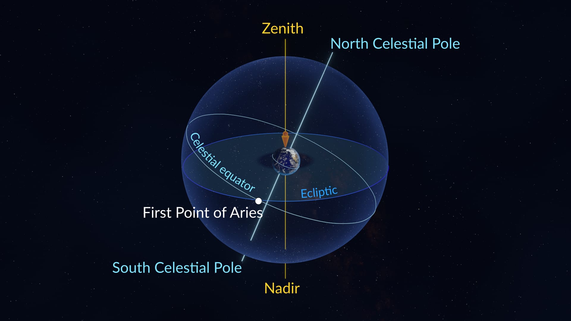
- Celestial equator: the circle along which the plane of the Earth’s equator crosses the celestial sphere. It divides the celestial sphere into Northern and Southern Hemispheres, just like the Earth's equator does.
- Ecliptic: the circle along which the Earth’s orbital plane crosses the celestial sphere. Due to the Earth’s axial tilt, the ecliptic and the celestial equator are at an angle of about 23.5° to each other. You can learn more about the ecliptic from our dedicated article.
- North Celestial Pole: the point on the celestial sphere directly above the Earth's North Pole where the Earth’s axis intersects the celestial sphere. It is a fixed point in the sky, and all stars appear to rotate around it in a counterclockwise direction.
- South Celestial Pole: the point on the celestial sphere directly above the Earth's South Pole where the Earth’s axis intersects the celestial sphere. Similar to the North Celestial Pole, it is a fixed point, and stars appear to rotate around it in a clockwise direction.
- Zenith: the point directly overhead an observer.
- Nadir: the point directly beneath an observer, opposite the zenith.
- First Point of Aries (vernal point): the point where the Sun crosses the celestial equator at the March equinox.
Now, let’s finally talk about the main coordinate systems used in astronomy.
Altitude & azimuth (Horizontal system)
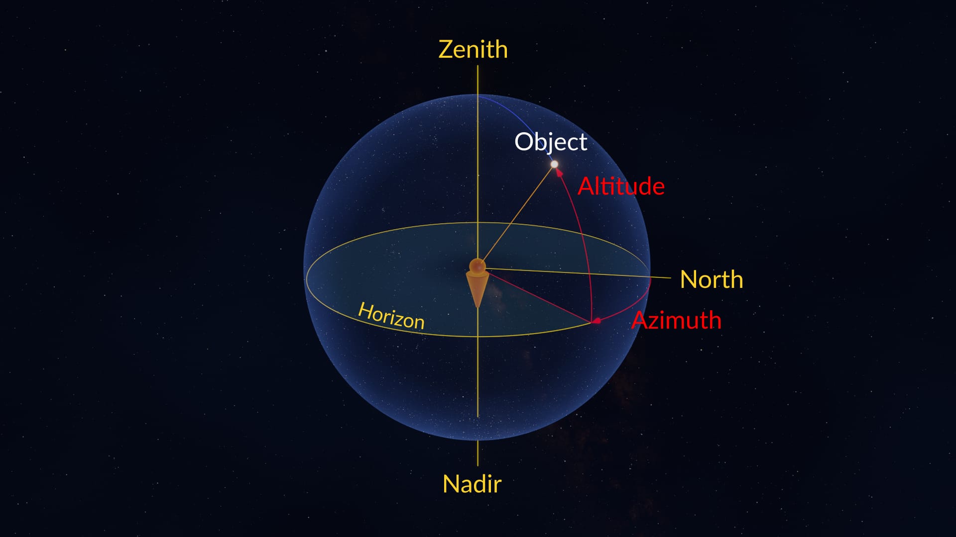
The horizontal coordinate system is a way to describe the position of sky objects relative to the observer’s horizon. It uses two main coordinates: altitude and azimuth.
-
Altitude represents the angular distance of an object above the observer's horizon. It is measured in degrees and ranges from +90° at the zenith to -90° at the nadir. For example, if a sky object is at an altitude of 45°, it would be halfway between the horizon and the zenith.
-
Azimuth indicates the position of an object along the horizon. It is measured in degrees clockwise from the true north — the direction that points toward the geographic North Pole. So, if an object has an azimuth of 90°, it would be due east from the observer, while an azimuth of 180° would be due south.
The horizontal coordinate system is particularly useful for casual stargazing, as it corresponds to the observer’s visual experience of the sky.
Declination & right ascension (Equatorial system)
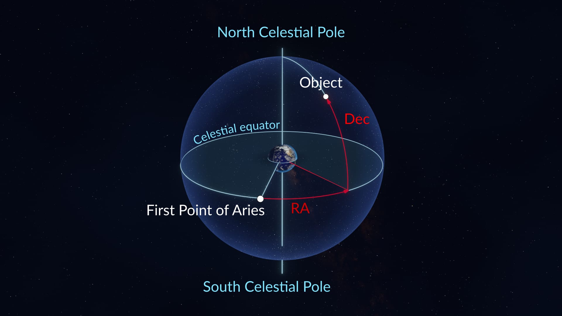
The equatorial coordinate system describes the positions of sky objects relative to the celestial equator. It uses two main coordinates: declination and right ascension.
-
Declination (Dec) measures the angular distance of an object north or south of the celestial equator. It is the celestial equivalent of terrestrial latitude. Declination is expressed in degrees, ranging from +90° (North Celestial Pole) to -90° (South Celestial Pole). For instance, if an object has a declination of +30°, it means it is positioned one-third of the way north of the celestial equator.
-
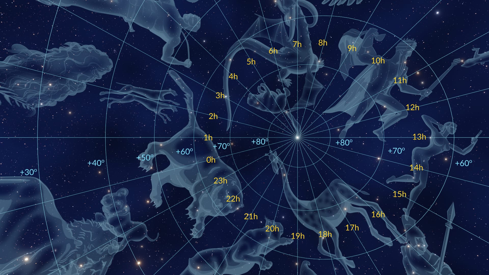
Right ascension (RA) measures the eastward angular distance of an object along the celestial equator, starting from the First Point of Aries. Right ascension is the celestial equivalent of terrestrial longitude. For historical reasons, it is expressed not in degrees but in hours, minutes, and seconds of arc. The Earth’s sky appears to turn 360° in 24 hours or 15° in one hour. Accordingly, the full 360° circle of the celestial equator corresponds to 24 hours of right ascension, and one hour of right ascension equals 15°. So, if an object has a right ascension of 6 hours, it means it is located 90° (15° × 6 hours) to the east from the First Point of Aries along the celestial equator.
The equatorial coordinate system can be geocentric (with the Earth in its center, as in the picture above) and topocentric (which depends on the observer's location). Many star maps use the geocentric equatorial coordinate system. If you’d like to use coordinates from such star maps to aim your telescope, you’ll have to convert them to topocentric equatorial or horizontal coordinates (there are special formulas to do that). Fortunately, there’s a much easier solution — to download a stargazing app like Sky Tonight, which uses topocentric coordinates. We’ll tell you more about how to use the app later in the article.
Ecliptic latitude & longitude (Ecliptic system)
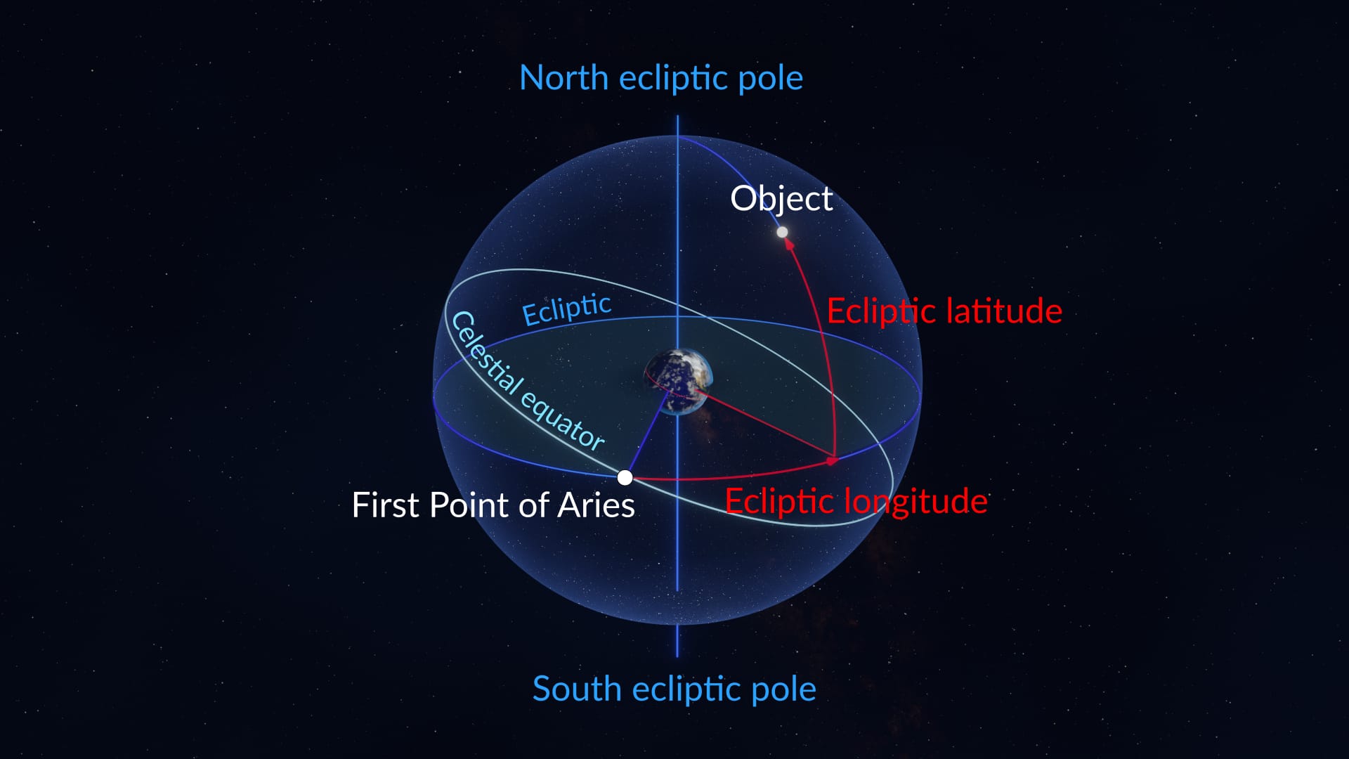
The ecliptic coordinate system describes the positions of sky objects relative to the ecliptic. It uses two main coordinates: ecliptic latitude and ecliptic longitude.
-
Ecliptic latitude measures the angular distance of an object north or south of the ecliptic plane. It is expressed in degrees, ranging from +90° (North Ecliptic Pole) to -90° (South Ecliptic Pole).
-
Ecliptic longitude is measured along the ecliptic plane and represents the angular distance of an object eastward from the First Point of Aries. Ecliptic longitude is expressed in degrees, ranging from 0° to 360°; the full 360° circle around the ecliptic corresponds to one year. So if an object has an ecliptic longitude of 90°, it means it is positioned one-fourth of the way around the ecliptic to the east from the First Point of Aries.
The ecliptic coordinate system is especially valuable for locating and tracking objects within the Solar System because it aligns with their orbital paths. It is widely used in observational astronomy, spacecraft navigation, and calculating phenomena such as planetary conjunctions and eclipses.
Other coordinate systems
Apart from the three celestial coordinate systems we’ve just discussed, astronomers also use the galactic and intergalactic coordinate systems. The former is used to study objects within the Milky Way galaxy, and the latter — to study the large-scale structure of the Universe. However, we won’t delve into them here in order not to complicate the article too much. The three systems we’ve mentioned will be quite enough for your practical needs.
How to locate an object using its coordinates?
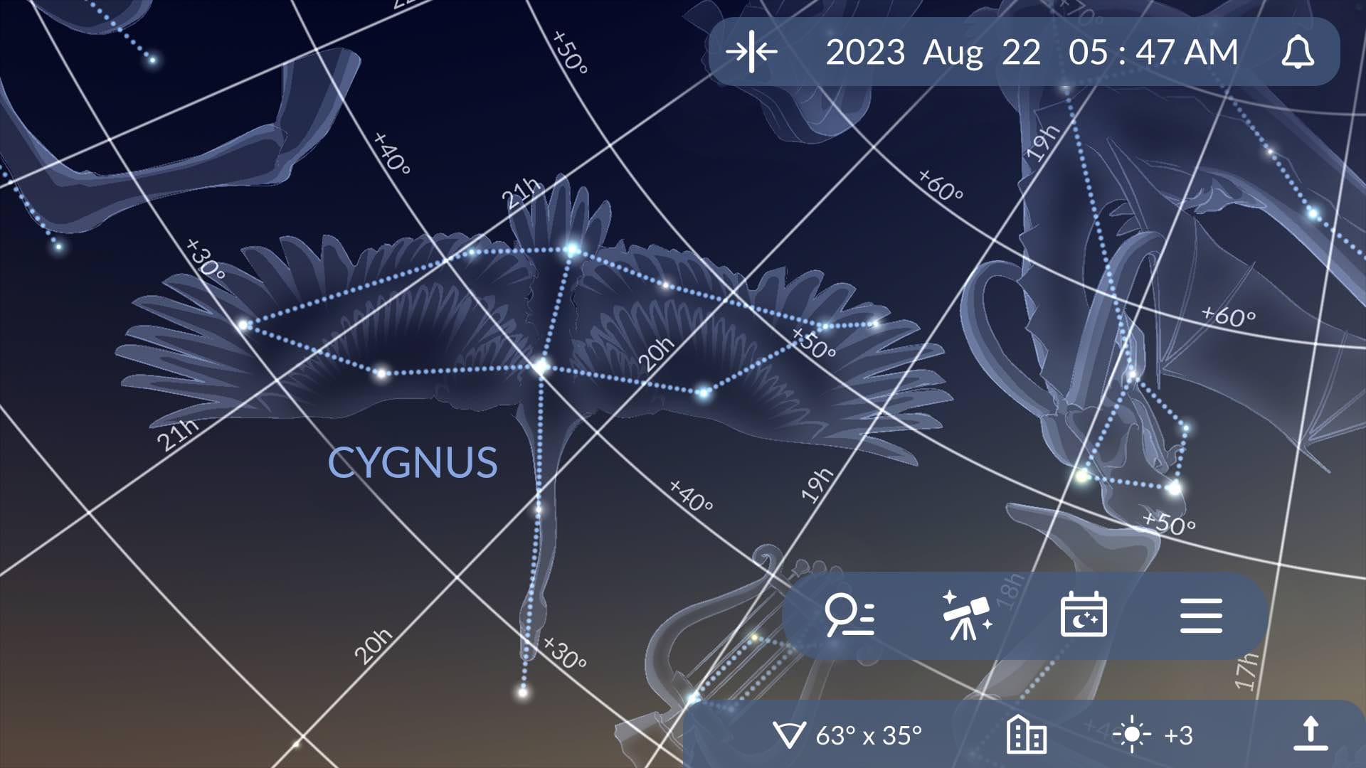
Now that you know about different celestial coordinate systems, it won’t be a problem for you to locate any object in the sky using your telescope. Here’s how to do it with the help of the Sky Tonight app.
- Make sure Sky Tonight is using your current location. Tap the Quick Settings panel at the bottom of the screen and check the location — it should be set to “Device location”.
- Overlay the grid. On the same panel, tap the globe icon once to overlay the equatorial grid on the sky map. Tap the icon twice to overlay the azimuthal grid on the sky map. The type of grid you should choose depends on your telescope’s mount.
- Get the coordinates of the object you want to see. Tap the magnifier icon at the bottom of the screen, type the object's name into the search field, and then tap on the object’s info card. After that, open the Figures tab. Here, you’ll find the object’s topocentric equatorial coordinates (RA, Dec) and horizontal coordinates (azimuth, altitude). Note that all coordinates are already given in relation to your location, so you don’t need to convert anything! After you’ve memorized or written down the coordinates, tap the blue target icon to see the object on the sky map.
- Now, you can aim your telescope using the equatorial or horizontal coordinates. Use the grid in Sky Tonight as an additional reference.
Interesting facts
Right ascension: why is it “right” and what ascends where?
Isn’t it weird that right ascension is equivalent to terrestrial longitude (which measures east-west positions)? One would think the word “ascension” is much better associated with latitude (which measures north-south positions). The thing is, in ancient astronomy, there was a term “right sphere” — it denoted a position of the celestial sphere where the celestial equator is perpendicular to the horizon (it can be observed on the Earth’s equator). On the right sphere, all celestial bodies will rise vertically — or, in other words, ascend rightly. So an object’s right ascension originally meant its ascension on the right sphere.
Declination = deviation
“Declination” might seem a strange term, too, if you don’t know its origin. Early astronomers used it to describe the distance by which the ecliptic “deviates” or “bends away” from the equator. If we take into account that the root of the word “declination” means “a bending away”, the term starts making sense.
First Point of Pisces?
The First Point of Aries used in the equatorial coordinate system is named after the zodiacal constellation Aries. During the time when the concept of the zodiac was established, the point where the Sun crossed the celestial equator at the March equinox was located in Aries. However, due to the phenomenon of precession, the First Point of Aries gradually transitioned into the neighboring constellation Pisces. So logically, it should have been renamed into the First Point of Pisces.
We live in the epoch J2000.0
Celestial coordinates change due to the precession of our planet’s axis. The precession leads to a westward drift of the equinox points at a rate of approximately 50.3 arcseconds per year. Consequently, the coordinate grid gets carried along with the shifting equinox points. To account for these changes, star catalogs and apps need to be regularly updated to a specific “epoch” that reflects the current position of celestial objects. The updating process is typically conducted every 50 years. Presently, most catalogs and apps employ epoch J2000.0 coordinates, which correspond to the year 2000. The next significant update is scheduled for 2050.
Bottom line
There are three main coordinate systems in observational astronomy: horizontal (altitude and azimuth), equatorial (declination and right ascension), and ecliptic (ecliptic latitude and longitude). Each of them is used for its own purpose, and together they enable astronomers and casual stargazers to precisely locate celestial objects and track their motions across the sky.
